Low pressure formed in the sea, will turn into a cyclone on Monday
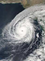
A low pressure has formed in the east-central Bay of Bengal. It will increase energy tomorrow morning and the next Monday, the low pressure will move north-northwest and turn north-northwest and turn into the north-north-west. Cyclone ‘Yash’ will become a cyclone. Today (May 22) India's weather department has published this news in the Anandabazar newspaper Online.
The forecast says that the cyclone will continue to progress and intensify in the next 24 hours from Monday, it will hit West Bengal by Wednesday evening. But it is not clear where it will hit. It is said that Bengal is likely to hit the coast. By the evening of May 26, the cyclone ‘Yash’ will cross the coast of West Bengal, North Odisha and Bangladesh, India's Alipur Abhawdhara is said to cross the coast.
The super cyclone may hit the coast of Bangladesh, so the entire coastal area will be issued a warning, said the Minister of State for Disaster Management and Relief. He gave this information at a press conference at the Secretariat on Saturday, Enamur Rahman.
Knowing that the ground is likely to hit the ground on May 26, he said, the speed of landing will be 120 to 190 km. It is currently close to Deeppunj, the Andaman Nicobar Deeppunj in the Bay of Bengal.